Expires:202307272015;;835641
FZUS51 KPHI 270856
SRFPHI
Surf Zone Forecast for New Jersey and Delaware
National Weather Service Mount Holly NJ
456 AM EDT Thu Jul 27 2023
NJZ026-272015-
Coastal Ocean-
Including the beaches of Long Beach Island
456 AM EDT Thu Jul 27 2023
.TODAY...
Rip Current Risk............Moderate.
Surf Height.................2 to 4 feet.
Thunderstorm Potential**....Moderate.
UV Index**..................Very High.
Water Temperature...........Around 70.
Weather.....................Mostly sunny.
High Temperature............In the upper 80s.
Winds.......................Breezy. Southwest winds 20 to 25 mph.
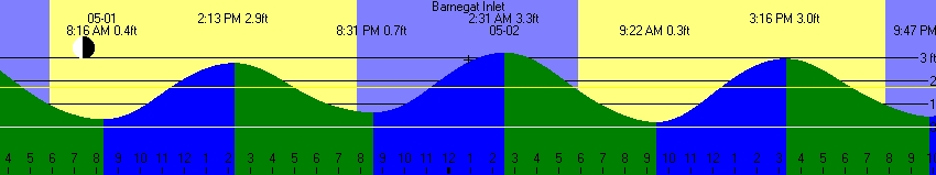
Tides...
Barnegat Inlet...........Low at 09:04 AM EDT.
High at 03:33 PM EDT.
Sunrise.....................5:51 AM.
Sunset......................8:15 PM.
.FRIDAY...
Rip Current Risk............Low.
Surf Height.................1 to 2 feet.
Thunderstorm Potential**....Low.
Weather.....................Mostly sunny.
High Temperature............Around 90.
Winds.......................Southwest winds around 5 mph,
increasing to south around 15 mph in
the afternoon.
Tides...
Barnegat Inlet...........Low at 10:06 AM EDT.
High at 04:33 PM EDT.
Sunrise.....................5:52 AM.
Sunset......................8:14 PM.
&&
Rip Current Risk Category
* Low Risk - The risk for rip currents is low, however,
life-threatening rip currents often occur in the vicinity of groins,
jetties, reefs, and piers.
* Moderate Risk - Life-threatening rip currents are possible in the
surf zone.
* High Risk - Life-threatening rip currents are likely in the surf
zone.
** For thunderstorm, waterspout, and UV definitions see:
https://www.weather.gov/beach/phi
$$
Top Bay Graph
Print Ocean Tide Table at Barnegat Inlet
Barnegat Inlet
Sandy Hook, New Jersey + Corrections: High(-0:21 *0.67) Low(-0:19 *0.67)
Units are feet, initial timezone is EDT
July 2023 low is -0.4ft, high is 4.2ft, range is 4.6ft.
Predicted historical low is -1.7ft, high is 5.2ft, range is 6.9ft.

  Sunday     Monday    Tuesday   Wednesday   Thursday   Friday     Saturday

   06-25   FQtr 06-26    06-27      06-28      06-29      06-30      07-01
H0047  3.0 H0131  2.9 H0219  2.8 H0313  2.7 H0413  2.7 H0516  2.8 L0030  0.1
L0717  0.5 L0805  0.6 L0858  0.6 L0949  0.5 L1040  0.4 L1131  0.3 H0615  2.9
H1342  2.9 H1426  3.0 H1511  3.1 H1601  3.3 H1654  3.5 H1748  3.7 L1224  0.2
L1936  0.9 L2043  0.9 L2146  0.8 L2243  0.6 L2337  0.4            H1839  3.9

   07-02   Full 07-03    07-04      07-05      07-06      07-07      07-08
L0123 -0.1 L0216 -0.2 L0306 -0.4 L0356 -0.4 L0444 -0.4 L0533 -0.4 L0623 -0.3
H0710  3.0 H0802  3.2 H0854  3.3 H0948  3.3 H1045  3.4 H1144  3.4 H1240  3.5
L1318  0.1 L1413 -0.0 L1507 -0.1 L1600 -0.1 L1653 -0.0 L1748  0.1 L1849  0.3
H1930  4.1 H2020  4.2 H2111  4.2 H2205  4.1 H2302  4.0 H2359  3.8

LQtr 07-09    07-10      07-11      07-12      07-13      07-14      07-15
H0054  3.5 H0149  3.3 H0245  3.1 H0343  2.9 H0444  2.8 H0543  2.8 L0046  0.2
L0716 -0.1 L0813  0.0 L0910  0.2 L1005  0.2 L1056  0.3 L1145  0.3 H0636  2.9
H1335  3.5 H1428  3.5 H1523  3.5 H1618  3.5 H1714  3.6 H1806  3.6 L1233  0.3
L1955  0.4 L2104  0.4 L2207  0.4 L2304  0.4 L2356  0.3            H1853  3.6

   07-16   New 07-17     07-18      07-19      07-20      07-21      07-22
L0133  0.2 L0217  0.1 L0259  0.1 L0337  0.1 L0413  0.1 L0447  0.2 L0519  0.3
H0723  2.9 H0807  3.0 H0850  3.0 H0931  3.0 H1013  2.9 H1055  2.9 H1136  2.9
L1319  0.3 L1405  0.4 L1448  0.4 L1528  0.4 L1607  0.4 L1644  0.5 L1722  0.6
H1935  3.7 H2015  3.6 H2054  3.6 H2131  3.5 H2208  3.4 H2245  3.3 H2323  3.1

   07-23      07-24   FQtr 07-25    07-26      07-27      07-28      07-29
L0550  0.3 H0002  3.0 H0046  2.9 H0134  2.8 H0230  2.7 H0335  2.7 H0445  2.7
H1215  3.0 L0622  0.4 L0700  0.5 L0751  0.6 L0857  0.6 L1002  0.5 L1103  0.4
L1803  0.7 H1254  3.0 H1335  3.1 H1421  3.2 H1515  3.3 H1616  3.5 H1719  3.7
           L1851  0.8 L1955  0.8 L2105  0.8 L2211  0.6 L2310  0.4

   07-30      07-31   Full 08-01    08-02      08-03      08-04      08-05
L0006  0.2 L0101 -0.1 L0155 -0.3 L0246 -0.5 L0335 -0.6 L0421 -0.6 L0507 -0.5
H0552  2.9 H0651  3.1 H0745  3.3 H0837  3.5 H0930  3.6 H1024  3.7 H1119  3.7
L1203  0.2 L1301  0.0 L1358 -0.1 L1454 -0.2 L1547 -0.3 L1639 -0.2 L1732 -0.0
H1818  3.9 H1913  4.1 H2005  4.2 H2057  4.3 H2149  4.2 H2242  4.0 H2337  3.7
Top Ocean Graph
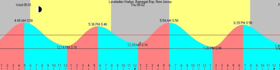
Print Tide Table for Loveladies Bay
Loveladies Harbor, Barnegat Bay, New Jersey
Sandy Hook, New Jersey + Corrections: High(+3:02 *0.10) Low(+3:39 *0.10)
Units are feet, initial timezone is EDT
Mark level: 0.00
July 2023 low is -0.1ft, high is 0.6ft, range is 0.7ft.
Predicted historical low is -0.3ft, high is 0.8ft, range is 1.0ft.

  Sunday     Monday    Tuesday   Wednesday   Thursday   Friday     Saturday

   06-25   FQtr 06-26    06-27      06-28      06-29      06-30      07-01
H0410  0.4 H0454  0.4 L0041  0.1 L0144  0.1 L0241  0.1 L0335  0.1 L0428  0.0
L1115  0.1 L1203  0.1 H0542  0.4 H0636  0.4 H0736  0.4 H0839  0.4 H0938  0.4
H1705  0.4 H1749  0.4 L1256  0.1 L1347  0.1 L1438  0.1 L1529  0.0 L1622  0.0
L2334  0.1            H1834  0.5 H1924  0.5 H2017  0.5 H2111  0.6 H2202  0.6

   07-02   Full 07-03    07-04      07-05      07-06      07-07      07-08
F0451 -0.0 F0512 -0.0 F0548 -0.0 H0034  0.6 H0128  0.6 H0225  0.6 H0322  0.6
L0521 -0.0 L0614 -0.0 L0704 -0.1 F0632 -0.0 F0719 -0.0 F0812 -0.0 F0913 -0.0
R0545 -0.0 R0702 -0.0 R0803 -0.0 L0754 -0.1 L0842 -0.1 L0931 -0.1 L1021 -0.0
H1033  0.5 H1124  0.5 H1217  0.5 R0858  0.0 R0947  0.0 R1032  0.0 R1114  0.0
L1716  0.0 F1800 -0.0 F1830 -0.0 H1311  0.5 H1408  0.5 H1506  0.5 H1603  0.5
H2253  0.6 L1811 -0.0 L1905 -0.0 F1922 -0.0 F2034  0.0 L2147  0.0 L2247  0.0
           R1820  0.0 R1933 -0.0 L1958 -0.0 L2051 -0.0
           H2343  0.6            R2027 -0.0 R2105 -0.0

LQtr 07-09    07-10      07-11      07-12      07-13      07-14      07-15
H0417  0.5 H0512  0.5 L0102  0.1 L0205  0.1 L0302  0.1 L0354  0.0 L0444  0.0
F1028  0.0 L1211  0.0 H0608  0.5 H0706  0.4 H0807  0.4 H0906  0.4 H0959  0.4
L1114 -0.0 H1751  0.5 L1308  0.0 L1403  0.0 L1454  0.0 L1543  0.0 L1631  0.1
R1150  0.0            H1846  0.5 H1941  0.5 H2037  0.5 H2129  0.5 H2216  0.5
H1658  0.5
L2353  0.1

   07-16   New 07-17     07-18      07-19      07-20      07-21      07-22
L0531  0.0 L0615  0.0 L0657  0.0 H0017  0.5 H0054  0.5 H0131  0.5 H0208  0.5
H1046  0.4 H1130  0.4 H1213  0.4 L0735  0.0 L0811  0.0 L0845  0.0 L0917  0.0
L1717  0.1 L1803  0.1 L1846  0.1 H1254  0.4 H1336  0.4 H1418  0.4 H1459  0.4
H2258  0.5 H2338  0.5            L1926  0.1 L2005  0.1 L2042  0.1 L2120  0.1

   07-23      07-24   FQtr 07-25    07-26      07-27      07-28      07-29
H0246  0.5 H0325  0.4 H0409  0.4 H0457  0.4 L0103  0.1 L0209  0.1 L0308  0.1
L0948  0.1 L1020  0.1 L1058  0.1 L1149  0.1 H0553  0.4 H0658  0.4 H0808  0.4
H1538  0.4 H1617  0.5 H1658  0.5 H1744  0.5 L1255  0.1 L1400  0.1 L1501  0.1
L2201  0.1 L2249  0.1 L2353  0.1            H1838  0.5 H1939  0.5 H2042  0.6

   07-30      07-31   Full 08-01    08-02      08-03      08-04      08-05
L0404  0.0 F0425 -0.0 F0445 -0.0 F0521 -0.0 H0020  0.6 H0112  0.6 H0205  0.6
H0915  0.4 L0459 -0.0 L0553 -0.0 L0644 -0.1 F0602 -0.0 F0648 -0.0 F0740 -0.0
L1601  0.0 R0527  0.0 R0646 -0.0 R0749  0.0 L0733 -0.1 L0820 -0.1 L0905 -0.1
H2141  0.6 H1014  0.5 H1108  0.5 H1200  0.5 R0843  0.0 R0930  0.0 R1012  0.0
           L1659  0.0 F1709  0.0 F1750 -0.0 H1253  0.5 H1347  0.6 H1442  0.6
           H2236  0.6 L1756 -0.0 L1852 -0.0 F1841 -0.0 F1942 -0.0 F2104 -0.0
                      R1832 -0.0 R1938  0.0 L1945 -0.0 L2037 -0.0 L2130 -0.0
                      H2328  0.6            R2033  0.0 R2119  0.0 R2151  0.0